Forging a New Path

Post by Alyce Shingler on July 2, 2016, updated on January 24, 2020

With the first operations utilizing performance-based navigation taking place in Europe, we take a look at how the concept may offer significant potential to improve reliability and safety in the helicopter industry.

By  Mario  Pierobon                     
As part of the PBN concept there exist two main macro-categories of navigation specifications: area navigation (RNAV) and required navigation performance (RNP). The main difference between RNAV and RNP  is the requirement for on-board performance monitoring and alerting. A navigation specification that includes a requirement for on-board navigation performance monitoring and alerting is referred to as an RNP specification. One not having such a requirement is referred to as an RNAV specification.. The capability to undertake performance-based navigation (PBN) for both rotorcraft and fixed-wing aircraft is one of the “future” navigation concepts being embraced by industry experts around the globe in the present. Representing a shift from sensor-based navigation, the PBN concept sees performance requirements identified in navigation specifications, which also identify a choice of navigation sensors and equipment to be used to meet the performance requirements.

According to the International Civil Aviation Organization’s (ICAO’s) PBN manual (Document 9613), the PBN concept specifies that aircraft RNAV and RNP system performance requirements must be defined in terms  of their accuracy, integrity, continuity and functionality.

Under PBN, generic navigation requirements are defined based on operational requirements. Operators then evaluate options in respect of available technology and navigation services, which could allow the requirements to be met. An operator thereby has the opportunity to select a more cost-effective option, rather than a solution being imposed as part of the operational requirements. Technology can evolve over time without requiring the operation itself to be reviewed, as long as the expected performance is provided by the RNAV or RNP system, according to ICAO.“The PBN concept suggests that RNAV specifications are effectively legacy specifications and that no new RNAV specifications will be developed,” states a PBN briefing paper from the European Organisation for the Safety of Air Navigation (Eurocontrol). “Indeed, PBN’s sights are firmly set on RNP which relies primarily on the use of satellite technologies. This explains why all the new navigation specifications in the 2013 update to the PBN manual are RNP specifications.”

FORGING A PATH

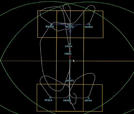
In Europe, some of the first applications of PBN have already taken place using the Localizer Performance with Vertical Guidance (LPV) approach and RNP 0.3, which are both part of the PBN family of navigation specifications.

In June 2015, a CHC Helikopter Service Sikorsky S-92 equipped with dual Universal Avionics SBAS-Flight Management Systems (FMS) car- ried out the first LPV approach to Florø, one of the first Norwegian air- ports to be equipped with LPV capability.

In Switzerland, Rega, one of the country’s leading helicopter emergency medical service (HEMS) providers, has been working closely   with the Swiss Air Force on a RNP 0.3 low flight network (LFN) that links hospitals as well as military airfields and landing sites. The Norwegian Air Ambulance is involved in a similar project to achieve an RNP 0.3 instrument flight rules (IFR) route net in Norway.

RNP 0.3 is a navigation specification for all phases of helicopter operations with a requirement for on-board navigation performance monitoring and alerting. Under this navigation specification, the required accuracy is 0.3 nautical miles (nm) for all phases of flight, which means that during operations in airspace or on air traffic service (ATS) routes designated as RNP 0.3, the lateral total system error must be within ±0.3 nm for at least 95 percent of the total flight time. The along-track error must also be within ±0.3 nm for at least 95 percent of the total flight time. To meet this performance requirement, a flight technical error of 0.25 nm (95 percent) may be assumed.

With regard to the navigation needs of helicopter operations, ICAO’s PBN manual highlights that: “The helicopter community identified a need for a specification that has a single accuracy of 0.3 nm for all phases of flight, recognizing that such a specification would enable a significant part of the IFR helicopter fleet to obtain benefit from PBN.”

According to ICAO, the operations envisaged by the helicopter community included reduced protected areas, potentially enabling separation from fixed-wing traffic to allow simultaneous non-interfering operations in dense terminal airspace, as well as low level routes in obstacle- rich environments to reduce exposure to icing environments. Seamless transition from en route to terminal route was also envisaged, as well as a need for more efficient terminal routing in obstacle-rich or noise-sensitive terminal environments — something particularly relevant to HEMS IFR operations between hospitals, and around airports supporting the offshore industry. Other operational needs leading to the development of the RNP 0.3 navigation specification included transitions to point in space (PinS) approaches and for departures.

OPERATIONS ENABLED

“Most modern IFR twins now come suitably equipped [for PBN] as standard,” Steve O’Collard, a technical pilot at CHC Helicopter, told Vertical. “In addition, there are after-market systems that are fully compatible.” According to Robert Clare, Universal Avionics’ director of sales, there are approximately 120 S-92s in the field with his company’s SBAS- FMS system installed.

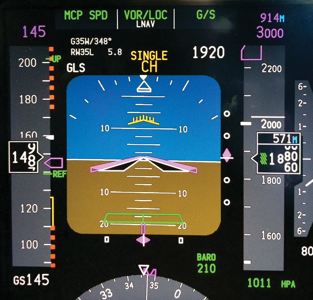
Indeed, significant benefits are enabled by LPV approach procedures  in that they allow approaches using on board global positioning system (GPS) rather than ground-based systems such as the instrument landing system (ILS). “LPV permits approaches to lower minima in cases where the local ground-based systems may not [such as VOR or NDB, which do not permit the same degree of accuracy], or where there are no ground-based systems, with potentially significant operational benefits,” said O’Collard. “The flight path is not affected by terrain interference; indeed ground-based signals can be ‘bent’ by terrain or by interference from, for example, other aircraft.”

With regard to PBN aeroplane operations, terminal and en-route navigation requires less navigation accuracy (RNP 1 and RNP 2, respectively). “ICAO PANS-OPS now allows RNP 0.3 operations for helicopters ‘in all phases of flight,’ ” said Lukas Kistler, lead pilot of Rega’s EC145 fleet. “This enables more flexible helicopter-dedicated en route IFR segments in difficult terrain with many restricting obstacles. By minimizing the size of the obstacle-free corridor, the routes can be designed at lower altitudes where generally warmer temperatures prevail. This in turn allows non de-iced helicopters to operate IFR on days where higher airways are already in an icing zone.”

In Europe, there are not many large-scale implementations of PBN for helicopter operations beyond the use of LPV approaches to aerodromes that have published RNP approach procedures to LPV minima. The acceptable means of compliance to the PBN section of European Aviation Safety Agency (EASA) air operations regulations dealing with operations that require specific approval aren’t even published for the RNP 0.3 specification. This means that operators wanting to implement RNP 0.3 — to derive the benefits of PBN for phases of flight other than the approach phase — must refer to ICAO’s PBN manual.

Kistler said that bad weather currently prevents around 600 people  from receiving emergency assistance from the air each year in Switzerland. “We see the possibility to increase the number of patients we are able to transport in marginal weather conditions [through the LFN],” he said. “We also believe that by routinely flying on an established, well known IFR network, we can further improve the level of safety as opposed to NVIS-aided VFR [visual flight rules] night operations.” According to Kistler, another setting where RNP 0.3 helicopter operations could provide benefit to both helicopter operators and wider air navigation systems are IFR transit routes through busy airspace at inter- national airports.

Over in the U.S., Hughes Aerospace Corporation, based in the Woodlands, Texas, is one of just two companies both endorsed by ICAO and certified by the Federal Aviation Administration (FAA) to develop, validate, and maintain FAA public (part 97) IFR procedures, as well as special IFR procedures for helicopter and fixed-wing operators worldwide. Hughes implemented the first public RNP approach procedures at Chicago O’Hare International Airport, which the company still maintains on behalf of the FAA. “We also develop and maintain helicopter PBN procedures,” Chris Baur, president and chief executive officer of Hughes Aerospace, told Vertical. “In the U.S., there are no IFR heliports, hence [helicopter] IFR procedures are categorized as special instrument procedures, developed as “PinS” or ‘Point in Space’ procedures. . . . There are [also] hundreds of special LNAV instrument approaches and departures, along with more contemporary LPV procedures.”

The company has worked with the FAA to prototype the use of the Wide Area Augmentation System (WAAS) and the use of “RF” (radius-to-fix) segment coding for

helicopters, leveraging the accuracy level and superior containment of WAAS and advanced ARINC 424 binary code. Baur noted that the FAA does not characterize helicopter RNP instrument approaches as RNP 0.3 naviga- tion, but it recently published criteria for RNP

0.3 IFR low level routes, supported by WAAS. Raw GPS has an accuracy of 10 meters, but if augmented by either space-based or ground- based augmentation systems, it can achieve accuracy levels of one meter and 10 centime- ters, respectively.

“In order to execute an RNP approach, you need to have special equipment and aircrew training,” said Baur. “The equipage requirements include dual flight management computers [FMC] and inertial reference systems [IRS]. In the event of a catastrophic reception failure of GPS updating to the FMC, the IRSs are used to perform an extraction maneuverer [missed approach], providing sufficient contain- ment until the aircraft is positioned at a safe altitude. Helicopters do not normally have a dual inertial reference system — the project we did with the FAA was to see illustrate how operators could use the containment accuracy of WAAS (SBAS) demonstrated at 0.3 RNP to alleviate the need to have [one].”

TECHNICAL AND OPERATIONAL REQUIREMENTS

For a helicopter company to perform PBN operations, O’Collard said it must first install equipment that satisfies the “aircraft requirements” of navigation specifications. Next, it must have operational approval from the applicable civil aviation authority to use the equipment. “This approval will cover not only normal and abnormal operational procedures, but also training,” he said.

ICAO’s PBN manual highlights that airworthiness certification and recognition of RNP 0.3 aircraft qualification alone does not authorize RNP 0.3 operations. “Operational approval is also required to confirm the adequacy of the operator’s normal and contingency procedures for the particular equipment installation applied to RNP 0.3 operations,” the manual states.

According to ICAO, the operating procedures to be developed, docu- mented and implemented include pre-flight planning, RNP 0.3 availability prediction, general operating procedures, RNP 0.3 standard instrument departure (SID) and standard instrument arrival route (STAR) specific requirements, as well as contingency procedures in case of loss of the RNP 0.3 capability.

The training program should provide sufficient training (in a simulator, training device, or aircraft) on the aircraft RNP system to the extent that the pilot is familiar with the content of the RNP 0.3 navigation specification in ICAO’s PBN manual. Flight crew training should also include required navigation equipment and minimum equipment list for operation on RNP 0.3 ATS routes and RNP system-specific information. Simulator and/or aircraft training should also be delivered to familiarize the flight crews with RNP equipment operating procedures and as contingency procedures.

To make it possible for the air navigation system to enable the high standards of PBN operations, a very peculiar system component comes into play: the variety of satellite based augmentation systems (SBASs) that operate in different regions of the world. While the GPS has been used successfully in aviation for many years, Universal Avionics said the basic technology does not produce adequate precision and accuracy to allow it to be used as a sole source of navigation. “The accuracy and integrity of GPS is greatly enhanced by the use of augmentation information from a variety of sources,” states a Universal Avionics’ document on SBAS. “[SBAS] augments the GPS signal to produce an increased accuracy, integrity, reliability and availability of information for aviation. With the decommissioning of legacy ground-based navigation systems, regional SBAS programs have grown substantially over  the past five years. This technology is a critical component of the FAA’s Next Generation [NextGen] program and the Eurocontrol SESAR [Single European Sky ATM Research] initiative.”

An SBAS consists of a network of precisely surveyed ground reference stations strategically positioned to monitor, collect and process satellite signals. The ground reference stations send satellite signal data to ground master stations, which then take measurements of signal delay and other errors (such as ionospheric and/or solar activity) that may impact the signal. Using the signal error measurements, master sta- tions develop corrections to the information obtained from the ground reference stations and send a corrected, or augmented, message to Geostationary Earth Orbit (GEO) communication satellites. These GEOs then broadcast the message to the internal SBAS receiver in an SBAS- capable FMS. Paul Damschen, Universal Avionics’ manager of airworthiness and flight operations, said the LPV approach does not require RNP 0.3 — in fact, it requires a much lower RNP value. “LPV approaches require a horizontal and vertical alarm limit of 50 meters, so positional accuracy to support those operations is much lower than basic RNP 0.3,” he said. “Basic RNP 0.3 does not require SBAS augmentation, and TSO C129 as well as TSO C146 equipment can support RNP 0.3 for en route, terminal, and approach. LNAV-only approach can be conducted under RNP 0.3, again, without SBAS augmentation.”

Several regional SBAS programs have been implemented so far, each complying with a common global standard. Therefore, all are compatible and interoperable, and do not interfere with each other. An operator with an SBAS-capable receiver can benefit from the same level of service and performance no matter which coverage area they are in. Existing and in-work SBAS include the WAAS in North America; the European Geostationary Navigation Overlay Service (EGNOS) in Europe and North Africa; the Multi-functional Satellite Augmentation System (MSAS) in Japan and GPS-Aided Geo-Augmentation Navigation (GAGAN) in the Indian subcontinent.

WHAT’S NEXT?

To achieve the high level of safety that RNP operations provide, espe- cially in terminal areas where approaches without a vertical glide path will be history, the airspace providers and the operators have a signifi- cant responsibility ahead of them. “While GSA in Europe is finalizing  the SBAS coverage to achieve lowest LPV minima at all airports, the national airspace providers at airports should be designing new RNP approaches to replace existing conventional approaches,” said Jørgen

Staffeldt, a type technical pilot of the S-92 at CHC Helicopter. “In parallel, the operators should be updating aircraft to SBAS capability and training the crew to achieve RNP authorization.

“On the other side, the helicopter OEMs should be working on the certification of aircraft to not just SBAS capability, but future NAV SPEC capability, including today’s RNP AR [Authorization Required] that cur- rently include Radius-to-Fix legs to be used in approach procedures, to achieve shortened and more flexible approaches,” Staffeldt continued. Baur noted that the several hundred public LPV procedures existing in the world are published for fixed-wing operations, while the majority of helicopter LPV procedures are special instrument approach procedures. “[Helicopter] instrument procedures in the United States are developed by third party service providers, such as Hughes Aerospace,” he said. “The FAA has issued Hughes with the authority to perform heliport evaluations, flight, simulator and obstacle evaluations as well as proce- dure maintenance.”

Baur notes that one of his company’s recent achievements has been to publish the first LP [Localizer Performance] helicopter approach procedure in the United States. “This type of approach provides sig- nificant benefit to the operator, in a situation where you are not able to provide the vertical guidance because the aircraft is WAAS [or SBAS] equipped but does not have the necessary equipage for LPV,” he said. “LP approaches provide lower minima than non-augmented LNAV approaches. The WAAS constellation supports a tighter accuracyand containment, with the potential to eliminate obstacles and reduce minima required with LNAV.”

PBN for rotary wing operations has significant potential to improve reliability and safety as well as air traffic management. However, it still has  to develop a critical mass. While the availability of technology installations and upgrades put PBN within easy reach for operators, without the sup- port of air navigation service providers (who must develop more public PBN procedures) and industry regulators (who must oversee the opera- tors wanting to upgrade to PBN capability), the benefit of PBN operations for the helicopter community will remain largely unfulfilled.
June/July 2016

United Flies First RNP Procedures in Micronesia

Post by Alyce Shingler on April 13, 2016, updated on January 24, 2020

Tuesday, April 12, 2016

United Flies First RNP Procedures in Micronesia

Woodrow Bellamy III

[Avionics Magazine 04-12-2016] United Airlines recently completed a project in the Federated States of Micronesia designed to take advantage of the advanced navigation capabilities of its airline fleet, increase safety, and generally make United pilot’s lives easier there. Working with FAA and ICAO’s third party Air Navigation Service Provider (ANSP) Hughes Aerospace Corp., the airline is now using Micronesia’s first ever Area Navigation (RNAV) Required Navigation Performance (RNP) procedures at Pohnpei International Airport.

RNAV RNP final approach at Pohnpei International Airport. Photo: Hughes Aerospace.

United is one of the only international carriers servicing the 6,800-foot runway at Pohnpei, and has needed the new procedures for years. The airport has no radar coverage, is surrounded by challenging terrain and has been limited ground-based and RNAV GPS approaches. With this in mind, the airline decided to take advantage of the advanced RNP navigation capabilities featured on its fleet of Boeing 737s.

“United has been flying to the islands of Micronesia for many years. Many of the islands, including Pohnpei, only had ground-based approaches known as Non-Directional Beacon (NDB) approaches. The FAA did add RNAV (GPS) approaches but they generally have paths across the ground similar to the NDB. In the case of Pohnpei, this meant the approach was at an angle to the runway. The new procedure offers a straight in approach so the pilots are lined up with the runway when they break out of the clouds,” Ron Renk, chief technical pilot at United Airlines told Avionics Magazine.

The new RNP procedures at Pohnpei provide United pilots with vertical guidance down to the runway surface, lowered instrument approach minimums from 920 feet and 3 miles, to 259 feet and 1 mile. Hughes Aerospace worked with United to complete the design, validation and publishing of the new procedures within four months, and the airline has now begun using them.

United will also now benefit from reduced fuel burn and carbon emissions at Pohnpei.

“The new approach offers many benefits over the approach it supplements. The flight path is optimized with is connection to the enroute airspace, saving fuel and CO2 emissions. It also has lower minimums, meaning we can more reliably get into Pohnpei even when there is [bad] weather. By far though, the best thing for us is the increase in safety offering a straight in approach versus the offset RNAV (GPS) approach,” said Renk.

Chris Baur, CEO of Hughes Aerospace, worked with Renk as a third party service provider to lead the deployment of RNP at Pohnpei. He told Avionics Magazine that the use of the new procedures are projected to lead to some significant fuel savings for United as well.

“We wanted to provide a stabilized approach, that lines up with the runway with vertical guidance to the surface, and the other thing we did is to reduce the amount of track miles to fly this procedure, by pulling them in closer to the island. We think that this procedure should save the airline $100,000 to $150,000 per year in fuel costs,” said Baur. “When we design a procedure, we try to get the lowest minimums at the highest RNP value, meaning we try to get the lowest minimums at a .3, so that the largest number of aircraft can have success operating an approach. But that’s not always possible, because of terrain, obstacles or other situations.”

The new approaches deployed at Pohnpei are similar to PBN procedures that the FAA has been deploying throughout the U.S. National Airspace System (NAS) under its NextGen program. According to the agency’s latest reported information, 59 percent of air transport category registered aircraft in the U.S. are equipped to perform RNP 1 with curved path procedures, while nearly 100 percent are equipped with avionics to fly more basic forms of PBN such as RNAV 1, RNAV 2 and RNP Approach.

Baur said one of the keys to deploying the new procedures in Pohnpei, is the process that the FAA has developed for redesigning airspace to allow properly equipped aircraft to choose the best path and approach to airports with challenging terrain.

“Even 10 years ago, the avionics for RNP were not consistent throughout the industry. And that’s changed and evolved significantly over the last 10 years. The FAA’s regulatory process has evolved significantly as well. That allows you to develop these types of procedures,” said Baur.

“I’ve been flying since 1979 and I’m blown away by how far we have come. The FAA deserves a lot of credit because they incubated, a lot of this. We have worked with them on it over the years; they are the ones who put this whole plan together. While I think they catch a lot of heat about NextGen, at least from our perspective we think they are doing a great job with NextGen and we enjoy the opportunity to work with them on the implementation of things like this,” he added.

– See more at: http://www.aviationtoday.com/av/navigation/87612.html?hq_e=el&hq_m=3234278&hq_l=2&hq_v=6f0a49e6a3#.Vw5tyfkrKM8 

Field Trip: Validating PBN Procedures At Airports

Post by Alyce Shingler on February 23, 2016, updated on January 24, 2020

Aviation Week & Space Technology
John Croft
Feb 19, 2016

A new breed of procedure designers is mapping fast lanes above and beyond.

Sky Architects

Building highways in the sky requires getting your feet dirty. Luckily, I wore boots the day I accompanied a team from Hughes Aerospace Corp. through the ranchlands of Cisco, a tiny rural town smack dab in the middle of Texas. Today’s job: validating a slate of new performance-based navigation (PBN) procedures that Hughes built  for the operators of a new airport in Cisco. At the edge of the Angle R property, adjacent to an approach path, a tree limited the minimum altitude for a certain approach; its height had to be verified for a final data package to be sent to the FAA for approval of the procedures.

route
A key step in gaining approval for PBN procedures is a validation flight, a track of which is shown in lavender for the new airport in Cisco, Texas. Credit: Hughes Aerospace

What is unusual at Gregory Simmons Memorial Airport is that the owners, with a small fleet of Cessna and Bombardier business jets, did not look to install any land-based instrument approaches: They jumped right into the future. That future will largely consist of approaches and departures defined by global navigation satellite systems (GNSS), GNSS augmentation systems, GNSS-based landing systems, or required navigation performance (RNP) avionics—rather than procedures linked to traditional land-based systems such as VORs or instrument landing systems. Along with lower costs—no ground infrastructure has to be purchased and maintained—PBN is more efficient, allowing for more direct routes, safe passage around obstacles and an associated reduction in fuel burned and carbon emissions. (more…)

Global PBN Deployment Arrives in Middle East

Post by Alyce Shingler on October 8, 2015, updated on January 24, 2020

Aviation Today :: Global PBN Deployment Arrives in Middle East

Woodrow Bellamy III

[Avionics Today 10-07-2015] Oman Air is using Performance Based Navigation (PBN) to simplify approaches into an airport with one of the most challenging terrains in its network, thanks to new procedure work performed by Hughes Aerospace and Honeywell. The national airline of Oman is currently flying the first Area Navigation (RNAV) approaches to be deployed in the region at Khasab Airport.

The Khasab Airport runway where Oman Air is now flying RNAV visual approaches. Photo: Hughes Aerospace.

According to Ricardo Jaramillo, manager of fleet training for Oman Air, the airport sits at the northeastern gulf coast of Oman with a number of different flight environmental challenges.

“Over the last three years we’ve started flying our ATR aircraft fleet into this airport, which is quite challenging. The airport is in between a valley, and you have mountains about 3,000 to 4,000 feet high surrounding it as well. The weather is also a challenge with high winds often creating a turbulent environment with a very limited flight envelope to operate within,” Jaramillo told Avionics Magazine. The Oman Air fleet manager also noted that the airline is introducing the Embraer 170 into its fleet, and the Oman civil aviation authority required a new approach into Khasab to allow them to start flying that aircraft to the airport used primarily for the military.

Hughes Aerospace CEO Chris Baur has been working in partnership with Honeywell Aerospace all over the world to implement PBN procedures and help airlines and operators deal with challenging terrain, reduce approach times and fuel burn during the approach phase of flight. At Khasab, Hughes, which is a globally credentialed third party Air Navigation Services Provider (ANSP) licensed to develop instrument procedures in Oman,  looked to introduce the RNAV Visual approach to deal with the airport’s unique challenges.

“RNAV Visual is a type of approach that we initiated in the United States with the FAA several years ago. The purpose of the RNAV Visual is allowing the [Flight Management Computer] FMC to provide guidance to the pilot for a stabilized approach onto a runway,” said Baur. “The challenge for Oman was getting in and out of Khasab and giving the pilots flight guidance; but they didn’t need guidance that was going to take them down to the approach minimums. Oman’s pilots were able to land the aircraft in [Visual Meteorological Conditions] VMC, but they just didn’t have a feasible approach. RNAV visual approaches give the aircraft a stabilized and well-defined path to and from the runway as long as the pilots can maintain VMC.”

Captain Jean Hersen, an Airbus flight operations expert, presented the benefits of the concept of operations for RNAV Visual approaches during an Airbus Winter Regional Seminar earlier this year. Hersen’s presentation cites research from an ICAO Operations Panel working paper on the concept of operations for RNAV visual approaches. According to Hersen’s presentation, the requirements for an RNAV visual approach are for storage and access from a Flight Management System (FMS) database. Also, the pilot of the aircraft must verify the aircraft capability matches navigation requirements for Radius to Fix (RF) leg capability and GPS accuracy. Flight crews can request RNAV visual approaches only upon verification that the required visual meteorological conditions exist, requirements are met, and the aircraft is in a position where the approach can be managed within the flight envelope of a normal approach.

Hughes Aerospace and Honeywell have been collaborating on similar PBN projects at airports in the Asia Pacific region, the United States and elsewhere, and Khasab marks the first deployment of an RNAV visual approach in the Middle Eastern region.

Back in the United States, Honeywell provides major support to such projects by adding the approaches that are coded and submitted to them by Hughes into their available software upload-able FMS navigation database.

“Hughes will develop the procedures and code them and then they send the information to us at the navigation database production group and we will build a navigation database. The database will then be tested. We fly it, we partner with our pilots group here at Honeywell, and we take it to our simulation bench and actually fly it to verify that the procedure flies correctly. We videotape it as well before sending the database to Hughes and the customer that’s going to do the flight validation and testing,” Scott Roesch, product support manager for the navigation database production team at Honeywell Aerospace told Avionics Magazine.

Roesch leads a team that updates 1,200 databases for various civil aviation authorities and operators all over the world every 28 days.

“Our database engineers, normally we go back and forth with the procedure designer at Hughes to make sure that the proper line types and path terminators are featured and everything that is associated with building the navigation database and the coding to spec is correct. Once it is error free, we take the ARINC 424 data and convert it into a binary format which is readable and useable on our FMS,” said Roesch. “We then build a database which is compatible to the specific aircraft FMS that will use the new procedures and make it available via our website. Whoever the customer is, whether it be the Oman Civil Air Authority, or an airline, we give them authorization to go onto our website, download the database, create it themselves on their specific media type and then they can load it onto the aircraft.”

Oman Air is now flying the new RNAV visual approaches at Khasab.

“We were lacking in a proper re-useable procedure, as we were relying on an internally created procedure, where we added some coordinates and we were following certain inputs into the [Global Navigation Satellite System] GNSS, essentially in a make-shift way. It was not an easy procedure so there were constant changes to the coordinates or the waypoints by the airline. But the one created by Hughes is an easy procedure, an easy database and nobody can modify it,” said Jaramillo.

The Khasab runway was recently resurfaced to support civil aircraft operations, although Oman’s air navigation authority required an instrument procedure for approval to use the airport.

“With a jet aircraft at Khasab, in order to get approval to fly there, we had to have an instrument procedure. This was the tool that gave us the approval because the Oman authority did not want the aircraft to land there without an instrument procedure. The RNAV Visual was the solution, because we did not have the capability for obtaining approval for [Required Navigation Performance Authorization Required] RNP AR,” Jaramillo explained.

Khasab could be the first of many RNAV Visual and other variations of PBN procedures introduced into the region, he added.

“This is a start; there is always a starting point and I think now we have changed the mentality of so many people here with the procedure, especially the authority. They saw it can be done and we are getting more confident. I believe there is room for another one here, and perhaps other areas throughout the region as well,” said Jaramillo.

http://www.aviationtoday.com/the-checklist/Global-PBN-Deployment-Arrives-in-Middle-East_86236.html#.VhZqQ9_rumE

Myanmar Implements its First PBN Procedures

Post by Alyce Shingler on August 27, 2015, updated on January 24, 2020

Wednesday, August 12, 2015

Woodrow Bellamy III

[Avionics Today 08-12-2015] Operators using Myanmar’s two busiest international airports, Mandalay and Yangon, can finally begin using Performance Based Navigation (PBN) practices after the country’s civil aviation authority approved and validated their first ever GPS-based procedures, which were badly needed in the country. Both airports have now unlocked the use of PBN, after flight validations were completed at the end of July through collaboration between experts from Hughes Aerospace and Honeywell.

Chris Baur, CEO of Hughes Aerospace, working with a team of Myanmar pilots to implement the country’s first PBN procedures.

Photo: Hughes Aerospace

Using a Cessna Caravan equipped with a retrofitted Garmin G1000 avionics package, Chris Baur, CEO of Hughes Aerospace, lead a team of Myanmar pilots through the first-ever PBN validation flight in Myanmar.

“The Department of Civil Aviation (DCA) of Myanmar wanted to implement their first ever [Global Navigation Satellite System] GNSS procedures starting with the main airport of Yangon. They wanted a GNSS procedure to both ends of the runway and then [Standard Instrument Departures] SIDS and [Standard Terminal Arrival Routes] STARS, based on GNSS,” Baur told Avionics Magazine. “The government was eager to get them implemented, and derive the benefit of having SIDS and STARS, which they haven’t had before. The traffic there is definitely growing quite quickly, so this should help to address that growth.”

Airlines and operators flying into both Mandalay and Yangon can begin using the new procedures immediately, Baur said. Operators will not be required to become certified or undergo any training there, as the majority of international carriers flying with modern aircraft have the avionics equipage and pilot training necessary to fly PBN procedures.

Like the rest of the country, Myanmar’s airspace was ruled by a military junta until 2012 and had never undergone modernization of its aviation infrastructure. Over the last several years though, the Myanmar government has been rapidly modernizing its economy, and its airports.

“Their initial excitement was to get into the PBN global movement and do this with GNSS approaches,” said Baur. “When we did the flight validation, we brought all of our own flight validation equipment and put it in their aircraft and conducted the flight validation and recorded the flight tracks. The aircraft flies the procedure and then we record the aircraft’s position independent of the aircraft system to validate it. What you’re mainly looking for, aside from recording flight tracks, is the ‘flyability’ of the procedure, ensuring that the aircraft is able to maintain the descent or maintain the crossing restrictions.”

While the initial benefits will mainly be around the safety and flight operational efficiency of aircraft flying into and out of Yangon and Mandalay, implementing PBN also serves as a foundation to manage future air traffic growth in the region. The Airbus Global Market Forecast for 2015-2034 has predicted that the Asia-Pacific region will lead the world in air traffic by 2034.

Myanmar is the second major GNSS procedures project that the Hughes-Honeywell partnership has completed this year, following the implementation of GBAS approaches in China early this year. Honeywell, like most other major U.S.-based suppliers, sees Myanmar and the greater Asia-Pacific region as a major area of growth for the global aviation industry. Growth begins with projects such as the recently completed ones in Myanmar, and continues with aircraft equipage and air traffic management modernization, according to Michael Underwood, director of business development at Honeywell Aerospace.

“We view the aviation ecosystem in the Asia Pacific as a high growth region,” said Underwood. “As such, we’re working across the full spectrum to help move and modernize not just the airplane fleets but the overall aviation infrastructure.”

Beyond Myanmar, Honeywell and Hughes are in similar talks with other Asian-Pacific countries for aircraft navigation modernization projects.

“We recently opened discussions with the civil aviation authority of Sri Lanka to talk about their PBN needs. They heard about what we have done in Myanmar,” said Underwood. “We’ve had similar discussions in Indonesia, the Philippines, so we’re very active in that region and working to help modernize the air traffic infrastructure there.”

– See more at: http://www.aviationtoday.com/av/topstories/Myanmar-Implements-its-First-PBN-Procedures_85774.html?hq_e=el&hq_m=3131201&hq_l=9&hq_v=c84bd0d89e#.Vd8JtflVikr

China Eastern, Shangdong Demonstrate GBAS at Pudong

Post by Alyce Shingler on May 27, 2015, updated on January 24, 2020

Woodrow Bellamy III

[Avionics Today 05-26-2015] China’s Civil Aviation Administration (CAAC) has unlocked a new capability for reducing delays and increasing efficiency at the country’s most congested airports that could be ready for live operational use by the end of this year. A recent flight demonstration by Honeywell and Hughes Aerospace showed the benefits of the SmartPath Ground Based Augmentation System (GBAS) for next generation GPS-based precision landings.

A cockpit display shows the GLS approach into Pudong Airport used during the April flight demonstration. Photo: Hughes Aerospace.

Using a China Eastern Airlines Airbus A321 and a Shangdong Airlines Boeing 737-800, flight crews demonstrated the first ever Global Navigation Satellite System (GNSS) instrument approaches in China at the end of April. To enable these precision landings, SmartPath’s four ground-based antennas take an aircraft’s GPS signals and sends them to a single box located on the airport, which then correlates the signals for a high degree of integrity before beaming it back up to the aircraft for precision landing guidance.

“The CAAC, knowing that they needed to have some very flexible alternatives to the legacy [Instrument Landing System] ILS, they asked us to do some very innovative approaches with the system,” said Brian Davis, vice president of airlines, Asia Pacific at Honeywell Aerospace. “Honeywell and our partner Hughes Aerospace, we actually designed and created the flight paths into Pudong airport, not only for the standard approaches but we did four very flexible innovative approaches that have never been done by a commercial airline before. The first one was what we called a displaced threshold, the second was a variable glide-path.”

Hughes Aerospace CEO Chris Baur also noted that the demonstrations were done in Instrument Meteorological Conditions (IMC), providing a real world flight environment for the airline pilots.

“We built GLS approaches to all of the runways at Pudong,” said Baur. “We built GLS approaches to 35L and 35R and 17L and 17R. Then we did something that hasn’t been done anywhere before where we built multiple GLS approaches to one runway. For Runway 35L, we built a straight-in GLS approach and variable geometric path approaches, one with a 2.8 degree flight path angle and one with a 3.2 degree flight path angle.

Baur said the team also built two non-linear curved path, or XLS, approaches for Runway 35L, and the approach was flown to an automatic landing in IMC conditions. The trial flights provided a demonstration that exploited all of the benefits of the SmartPath technology, such as the ability to merge GLS with Required Navigation Performance (RNP) procedures to create a custom path to the runway based on the type of aircraft being flown.

Hughes Aerospace CEO Chris Baur and the flight crew from Shangdong Airlines that performed the precision landings demonstrations. Photo: Hughes Aerospace.

Davis says the implementation of the new procedures at Pudong can provide a model for dealing with wake turbulence issues from different aircraft as well. With heavier aircraft such as Boeing 747s, 777s or Airbus A380s dispersing an enormous amount of wake turbulence from the wings, aircraft in trail behind them are often forced to maintain very lengthy separation distances. An airport as busy as Pudong can face huge efficiency challenges when this happens.

“The variable glide-path allows the SmartPath station to send a signal to the aircraft that will allow it to fly a 2.8 or 2.9 or basically any glide-path you would like. It allows pilots to fly a much shallower glide-path than they would with an ILS,” said Davis. “SmartPath allows for up to 26 different approach combinations. That means for the same runway you can have an approach at a 2.8 degree glide-path. That’s where you bring the A380s and the Boeing 777s in. To the exact same runway, you can actually have the SmartPath station send a signal on a different channel to the smaller aircraft that will allow it to come in at a 3.1 degree glide-path, for example, so wake turbulence always disperses downward. If we bring those larger aircraft in at a shallow glide-path and the smaller aircraft in at a steeper glide-path, that means the 737 and A320 are always above the wake turbulence footprint of the larger aircraft.”

SmartPath has already been deployed in Australia, Brazil, Germany, Spain and Switzerland, and CAAC sees it as one of the key tools for managing future increases in air traffic. The International Air Transportation Association (IATA) expects China to have 415 million air travel passengers annually by 2016, which would be second only to the United States in domestic passenger volume.

According to Davis, the majority of aircraft coming off of production lines today are equipped with Multi-Mode Receivers (MMR) capable of performing GBAS landings and the localizer guidance and glide slope guidance for a SmartPath approach looks the same to a flight crew as if they were flying an ILS approach.

Going forward, the new procedures must now be certified by the CAAC and Air Traffic Management Bureau.

“We should have this station up and certified by the end of 2015, or the early part of 2016 with many airlines ready to fly the new GBAS procedures shortly thereafter,” said Davis.

– See more at: http://www.aviationtoday.com/av/commercial/China-Eastern-Shangdong-Demonstrate-GBAS-at-Pudong_85121.html#.VWXotflVikq

China Advances In Satellite-Based Landings

Post by Alyce Shingler on May 13, 2015, updated on January 24, 2020

John Croft | Aviation Week & Space Technology           May 12, 2015

China leapfrogged its international peers in late April with what is arguably the world’s most advanced display of a precision navigation capability—satellite-guided curved approaches with multiple glideslopes that seamlessly terminated in automatic landings.

The one-day demonstration on April 29 took place at Shanghai’s Pudong International Airport using a China Eastern Airlines Airbus A321 and a Shangdong Airlines Boeing 737-800 with senior officials from China’s Civil Aviation Administration (CAAC) and air traffic management bureau onboard. Anchoring the capability is a Honeywell SmartPath ground-based augmentation system (GBAS) that has been operating at the airport since January.

The approaches at Pudong demonstrated key benefits of a digital GBAS landing system (GLS), including the ability to merge the GLS with satellite-based required navigation performance (RNP) procedures for a customized 3-D path to the runway. RNP provides the aircraft with narrow horizontal and vertical paths into the vicinity of an airport, where GLS provides the precision guidance to landing. The SmartPath system, the first certified GBAS landing system to be installed in China, uplinks digitized approach paths and correction factors to GPS signals to allow an aircraft equipped with a multi-mode receiver capturing GPS signals from space and the GLS information from the ground station to fly as many as 26 approaches to multiple runways. A GLS can replace or augment traditional instrument-approach architectures that use analog horizontal and vertical guidance transmitters placed at each runway end to transmit a straight-in path to the runway, typically at a 3-deg. glideslope. Those systems are costly to maintain and require flight inspections on at least a semi-annual basis.


A GLS approach into the Pudong Airport as seen on the primary flight display of an aircraft participating in a late-April demonstration of satellite-guided curved approaches. Credit: Hughes Aerospace


Navigation procedure developer Hughes Aerospace drafted eight approaches for Pudong in partnership with Honeywell. Included are GLS procedures for Runway 35L that offer a traditional straight-in approach with 3-deg. glidepath, a curved approach that mates with an RNP arrival and intersects a straight-in GLS final, a straight-in approach with 2.8-deg. glidepath and a straight-in approach with a 3.2-deg. glidepath and a 3,517-ft. displaced threshold. RNP approaches with curved paths can be used to join with a GLS approach closer to the airport, saving track miles and fuel compared to legacy approaches, or to avoid noise-sensitive areas.

Chris Baur, president and chief executive of Hughes Aerospace, says choices for glidepath angle potentially could allow airports to increase runway throughput by mitigating wake turbulence concerns. For example, the arrival rate could be increased by having a heavy aircraft fly an approach with a lower glidepath while a lighter aircraft uses the steeper glidepath approach with displaced threshold.

SmartPath, to date the only FAA-certified GLS on the market, is installed at several airports worldwide, including Newark (New Jersey), Houston, Frankfurt and Sydney, where a growing number of aircraft equipped with multi-mode receivers (MMR) can access the capability. The systems are currently approved for Category 1 instrument approach minimums (aircraft must be in visual conditions at 200 ft. above the runway to continue the approach), but the FAA and others are working toward Cat. 2 (100-ft. minimums) and Cat. 3 capability (50-ft. minimums or less, including autoland) in the next several years. The FAA says Cat. 3 operations could be available in the U.S. in 2018.

A handful of airlines globally are beginning to use GLS as an alternative to a straight-in legacy instrument landing system (ILS) with a 3-deg. glideslope, particularly as newer aircraft are available from the factory with the option. Boeing says it has more than 1,000 GPS-equipped in-service aircraft, with the number growing by 25 per month. The airframer says one-third of all new 737s are being delivered with the MMRs, which are standard equipment on the 747-8 and 787.

Delta Air Lines conducted its inaugural GBAS landing with a Boeing 737 at Newark Liberty International Airport on Feb. 18, joining United Airlines and British Airways, which were already flying the approaches there. The FAA says United is averaging 65-70 GBAS landing system (GLS) approaches at Newark and Houston’s George Bush Intercontinental Airport each month with a portion of its 737 and 787 fleets. United has 95 737s and 14 787s with MMR avionics, and is selecting the option for all new 737s.

Delta is using the approaches in Houston as well as in Newark, and has a fleet of 42 GLS-equipped 737s. The carrier is investigating GLS for its Airbus fleet. In total, the airline plans to have 177 aircraft equipped for the approaches by 2019, according to the FAA. A growing number of international airlines also are using the capability at Newark and Houston. Emirates conducted its first GLS landing in Houston in December with an Airbus A380, one of 57 GLS-equipped A380s at the time. The carrier also uses the approaches at Frankfurt, Sydney and Zurich. Lufthansa made its first GLS landing in Houston in December with one of 12 equipped A380s that also use the approaches at Sydney and Frankfurt. Cathay Pacific made its first GLS landing in Houston, with a 747-8, at the end of January. The FAA says Virgin Atlantic is also planning to seek operational specification approval for the approaches into Newark. Other carriers purchasing GLS-equipped aircraft include Air Berlin, Qantas, Swiss, TUIfly and various Russian airlines.

Next steps for Pudong include CAAC certification of the GLS at the airport, an inaugural process that may allow for quicker installations at other airports in the country.

http://aviationweek.com/commercial-aviation/china-advances-satellite-based-landings

China Demonstrates GPS-Based Instrument Landing System

Post by Alyce Shingler on May 7, 2015, updated on January 24, 2020

John Croft | Aviation Daily

A China Eastern AirlinesAirbus A321 and a Shandong Airlines Boeing 737-800 flew a series of instrument approaches to the Shanghai Pudong International airport on April 29 using a Honeywell-built ground-based augmentation system (GBAS) and instrument-approach procedures developed by Hughes Aerospace, marking the first public demonstrations of the technology in China.

The Honeywell SmartPath GBAS landing system (GLS)—which augments GPS signals to boost accuracy to required levels—is the first certified system to be installed in China. One GLS, which can output guidance for up to 26 approaches to any runway, replaces traditional instrument-approach architectures that require horizontal and vertical guidance systems to be placed at each runway end. The single system covers approaches for all four runways at Pudong and saves on a variety of regular inspection and maintenance costs.

SmartPath, to date the only FAA-certified system on the market, is installed at several airports around the world, including Newark, Houston, Sydney and Frankfurt. The GLS is currently approved for Category 1 (Cat 1) instrument approach minimums (aircraft must be in visual conditions at 200 ft. above the runway to continue the approach), but the FAA and others are working toward Cat 2 (100-ft. minimums) and Cat 3 capability (50-ft. minimums or less, including autoland) in the next several years. The FAA says Cat 3 operations could be available in the U.S. in 2018.

Other “firsts” on April 29 include the demonstration of curved approaches that connect to the GLS, and approaches with lower- or higher-than-standard glideslopes, including a 2.8-deg. flight path angle (FPA), a 3.2-deg. FPA and the standard 3.0-deg FPA. The 3.2-deg. FPA approach also included a displaced threshold of 1,072 ft., an offset that could help avoid the potential for wake turbulence during parallel runway operations, Hughes Aerospace CEO Chris Baur said.

Hughes, which is partnered with Honeywell on the project, is one of three FAA-certified third-party providers of NextGen procedures. Baur said the company built eight approaches into Pudong. The two commercial aircraft each flew 4-5 non-revenue approaches in instrument weather that day, he said.

Next steps for Pudong include certification at the airport by the China’s Civil Aviation Administration (CAAC) and Air Traffic Management Bureau, a process that may allow for quicker installations at other airports in the country.

http://aviationweek.com/commercial-aviation/china-demonstrates-gps-based-instrument-landing-system

Bell, Hughes Explore PBN for Operators in China

Post by Alyce Shingler on March 6, 2015, updated on January 24, 2020

BUSINESS AVIATION

Bell, Hughes Explore PBN for Operators in China by Kerry Lynch –

March 5, 2015, 11:24 AM

Bell Helicopter, teamed with Hughes Aerospace, is exploring the development of performance-based navigation (PBN) procedures for Bell operators in China equipped with advanced navigation systems. PBN defines navigation performance requirements for air-traffic routes and instrument procedures. The procedures would enable the helicopter operators to optimize access to airspace, flying more direct approaches and departures than they would otherwise under IFR-base routes or those designed for fixed-wing aircraft, said Chris Jaran, vice president for Bell Helicopter in China. “The flexibility PBN delivers to operators translates into less fuel burned and time in the air, effectively increasing the number of flights a helicopter can perform before requiring maintenance,” added Hughes Aerospace president and CEO Chris Baur.

http://www.ainonline.com/aviation-news/business-aviation/2015-03-05/bell-hughes-explore-pbn-operators-china

SESAR Launches Major Flight Demonstration Project for Augmented Approaches

Post by Alyce Shingler on December 27, 2014, updated on January 24, 2020

Tuesday, December 23, 2014

Woodrow Bellamy III

[Avionics Today 12-23-2014] A new consortium formed by the Single European Sky ATM Research Joint Undertaking (SESAR JU) will perform more than 200 demonstration flights at airports throughout Europe to validate new approach and landing technologies. The new consortium, called Advanced Approaches for all Airports (A3), is looking to use the demonstration flights to develop new approach and landing solutions that will increase air traffic throughput while also reducing aircraft emissions and noise over communities located near airports throughout Europe.

Computer rendering of an RNP approach into an airport runway. Photo: Hughes Aerospace.

NetJets Europe is leading A3’s demonstration flights, named the Augmented Approaches to Land project (AAL). The project will use advanced approach and landing procedures based on five different technologies; curved Required Navigation Performance paths (RNP), Ground and Satellite-based Augmentation Systems (GBAS and SBAS), Synthetic Vision Guidance System (SVGS), and Enhanced Flight Vision System (EFVS).

These different approaches provide benefits for operators with more efficient flight paths into airports, as well as the airport itself, as they eliminate reliance on inflexible ground-based Instrument Landing System (ILS) equipment. GBAS systems are designed for aircraft equipped with GPS landing system technology, which most current production Airbus and Boeing airplanes feature.

“It will demonstrate that augmented vision and satellite-based augmented navigation can improve the access while reducing the environmental impact of all types of airspace users into all types of airports,” said Jean-Phillippe Ramu, SESAR project manager, second in command Gulfstream V/550 at NetJets Europe. “We believe that the project will show what will be the approach and landing operations of tomorrow.”

One of the more progressive aspects of the demonstration will be the trials that feature the use of synthetic vision technology. SVGS technology, such as Honeywell’s SmartView system, provides a three-dimensional view of an airborne aircraft’s surrounding terrain, obstacles, airports and runways. Honeywell has applied for a Supplemental Type Certificate for SmartVision Lower Minimums (SVLM) that, if certified, would allow pilots to navigate using synthetic vision down to a 150 feet decision height with visibility as low as 1,400 feet.

Curved noise abatement Required Navigation Performance (RNP) procedures with transitions to satellite navigation based approaches (GBAS and SBAS) will be demonstrated during the trials. A3 also has a goal of developing and publishing new airport procedures during the demonstration period.

Deploying more Performance Based Navigation (PBN) procedures, such as those mentioned above, is one of the top goals of the overarching Single European Sky project in Europe and the NextGen Air Traffic Management (ATM) modernization project in the United States. During a recent interview with Avionics Magazine, Chris Baur, president and CEO of Hughes Aerospace Corp., discussed the benefits of eliminating operator and airport reliance on ILS equipment. In 2013, Hughes lead the effort to establish the first public RNP procedure at the world’s busiest airport, Chicago O’Hare.

“There’s really no business case for legacy navaids anymore. Its just a horrific expense, you have to constantly calibrate them, validate them, maintain them, and you’re limited as to how you can operate,” said Baur, who is also a commercial airline pilot.

“Everything with these legacy navaids is also linear you have to fly out to catch your radio beam and track it inbound. The GBAS, the [GNSS Landing System] GLS approaches, the RNP approaches, the PBN catch all eliminates all of that,” he said.

Honeywell and Elbit Systems will be supplying the avionics for the demonstrations, while Dassault Aviation andAirbus will provide airframe manufacturer and aircraft systems support. Lufthansa and Swiss Airlines will also participate in the demonstration flights, which will occur at small and medium airports including Perigueux, Bergerac, Bordeaux, Ostrava and Bremen, as well as large airports Frankfurt and Zurich.

http://www.aviationtoday.com/the-checklist/SESAR-Launches-Major-Flight-Demonstration-Project-for-Augmented-Approaches_83821.html#.VJ7LmF4ACY