By John Croft, Aviation Week & Space Technology
A new breed of procedure designers is mapping fast lanes above and beyond.
Building highways in the sky requires getting your feet dirty. Luckily, I wore boots the day I accompanied a team from Hughes Aerospace Corp. through the ranchlands of Cisco, a tiny rural town smack dab in the middle of Texas. Today’s job: validating a slate of new performance-based navigation (PBN) procedures that Hughes built for the operators of a new airport in Cisco. At the edge of the Angle R property, adjacent to an approach path, a tree limited the minimum altitude for a certain approach; its height had to be verified for a final data package to be sent to the FAA for approval of the procedures.
What is unusual at Gregory Simmons Memorial Airport is that the owners, with a small fleet of Cessna and Bombardier business jets, did not look to install any land-based instrument approaches: They jumped right into the future. That future will largely consist of approaches and departures defined by global navigation satellite systems (GNSS), GNSS augmentation systems, GNSS-based landing systems, or required navigation performance (RNP) avionics—rather than procedures linked to traditional land-based systems such as VORs or instrument landing systems. Along with lower costs—no ground infrastructure has to be purchased and maintained—PBN is more efficient, allowing for more direct routes, safe passage around obstacles and an associated reduction in fuel burned and carbon emissions.
Only three U.S. companies are FAA-approved to create, validate and maintain the instrument flight procedures for third-party service providers: Hughes, Boeing subsidiary Jeppesen and GE Aviation. However, any business aviation operator or airline can develop its own procedures and seek regulatory approval. Alaska Airlines, an early adopter of RNP Authorization Required (RNP AR) approaches—which allow an aircraft to fly a precise path through challenging terrain to access remote airports—has developed more than 50 procedures on its own.
The FAA itself has a fairly large contingent of terpsters insider slang for developers of approach and departure procedures that adhere to U.S. design rules, known as Terps (terminal instrument procedures)”at its Mike Monroney Aeronautical Center in Oklahoma City developing the procedures at no cost to requesters, but it has a large backlog. According to the FAA, someone requesting a new approach at an airport such as Cisco’s may have to wait 2-4 years to see the results. International procedures typically follow the International Civil Aviation Organizations Pans-Ops criteria, similar to Terps except for certain design elements. To date, the FAA has approved nearly 15,000 PBN procedures, not including RNP approaches, far outnumbering the nearly 5,000 traditional procedures, the total of which is relatively static compared to the fast-growing PBN variety.
Houston-based Hughes can complete the process in 6-9 months, sometimes less. The company operates its own aircraft to accelerate the process for U.S. and global clientele—including in China, the Philippines, Oman, the United Arab Emirates, Myanmar and Saudi Arabia—that ask for a mix of airline, business aviation and helicopter approaches and departures.
Hughes recently completed the first public RNP AR approach at Micronesias Pohnpei International Airport at the request of United Airlines. Including development, validation and approval by the FAA (which oversees the airspace), the approach took four months to complete. United operates a handful of flights per week into the island with Boeing 737s. A legacy GPS approach for Runway 9 has a minimum descent altitude of 920 ft. and required visibility of 3 mi., relatively high minimums set in part because the approach does not line up on the runway centerline due to terrain, and there are no approach lights, as the runway end is surrounded by ocean. The missed approach procedure is not optimal either, calling for pilots to fly 30 nm away to a holding pattern, potentially adding fuel-quantity stress if the aircraft ultimately has to return to its departure airport
Hughes RNP AR horizontally and vertically guided approach features minimums of 250 ft. above the runway and 1 mi. visibility, with a missed approach procedure that puts the aircraft in an oval holding pattern at the approach’s starting point, close to the airport. “The GPS approach is how someone who builds instrument procedures would want to design this,” says President Chris Baur. “Mine is how a pilot would want to fly it.” Baur, a veteran airline, business-aviation and helicopter pilot, estimates United will save $100,000-150,000 a year in fuel even with limited use of the procedure.
At Cisco, the operator hired Hughes to build a series of PBN procedures for both runway ends, with associated terminal arrival and departure routes, to allow for instrument flight rules procedures with minimums as low as possible. While service providers such as Hughes do not discuss prices for competitive reasons, a contract the FAA issued in 2012 lists RNP procedures at approximately $275,000 each, including maintenance. Maintenance generally includes daily checks of new obstacles that could affect the approach, Notices to Airman service if alerts are needed and an FAA-required review of airspace and obstacle validation every 1.5 years, or in some cases an inflight revalidation of the procedure. Baur says Hughes can develop and maintain instrument flight procedures for less than the FAA estimate, based on its expertise and efficiency.
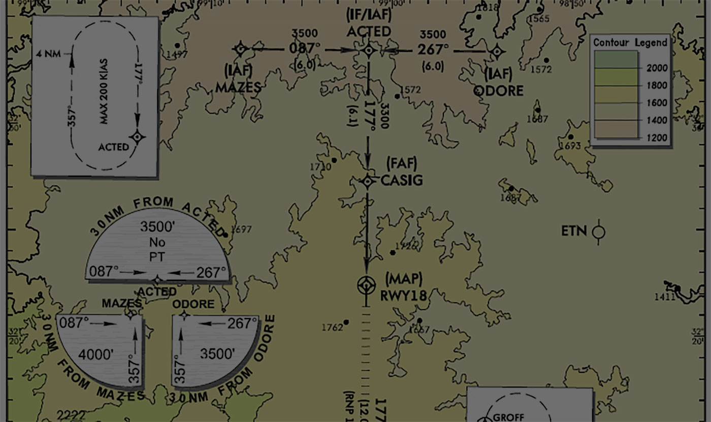
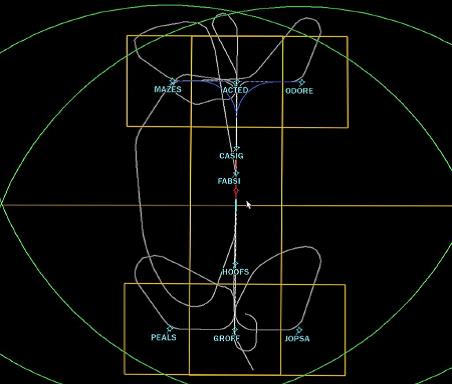
Once customer requirements are set, procedure designers come up with a concept, discuss the ideas with local air traffic control, and obtain survey data to identify terrain and obstacles that could affect the desired courses and altitudes. Which is where the tree on Angle R Ranch, officially known as Tree 5095, came in. In Terps, an approach is split into four segments-—initial, intermediate, final and missed approach—and each has an associated minimum altitude based on the highest obstacles (known as the controlling obstacle in Terps and critical obstacle in Pans-Ops) and the type of avionics being used for the approach. For example, a localizer performance with vertical guidance (LPV) approach that uses the more accurate Wide Area Augmentation System (WAAS) GPS input to the avionics will yield lower minimums than a basic GPS approach, due to greater position accuracy. Likewise, an RNP approach that requires an aircraft to stay within precise lateral limits can sometimes yield lower minimums since obstacles outside those bounds—called the linear containment area—can be ignored.
While the airport owners had desired an LPV approach with typical minimums of 200-250 ft. on Runway 36, Tree 5095, located just off the centerline of the final approach on a neighbors property, poked through an imaginary plane, called the glidepath qualification surface, that extends from the runway end and provides a safety buffer for an approach that might be flown too low. Hughes was able to save the tree and still get close to LPV minimums, however, with a GPS WAAS localizer performance approach with a 309-ft. minimum altitude. The tree posed another issue”its height impinged on a second imaginary 20:1 visual surface that rises 1 ft. vertically for every 20 ft. horizontally, prohibiting nighttime operations. Hughes worked with the airport, which worked with the neighbor to solve the problem by placing a red obstruction light on a pole adjacent to and slightly higher than the tree, allowing for typical growth.
We walked property both on and off the airport to verify the actual height obstacles, including Tree 5095, for the FAA approaches-approval package. The validation activity typically occurs at the tail end of the procedure development process, a necessarily complex and burdensome endeavor, given the nature of what is at stake: guiding an aircraft, typically a very large and expensive aircraft with numerous passengers, down to within feet of the ground in practically any weather, day or night.
With the clients needs known, the process generally starts with a site evaluation and surveys to obtain airport and obstacle data. Hughes uses several different software tools to develop instrument flight procedures to either Terps or Pans-Ops criteria while evaluating terrain and obstacle data. Once the procedure is built and accepted by the customer, Hughes creates a test navigation database for the flight validation aircrafts flight management system, a step completed in this case by Honeywell for the airport owners Honeywell Primus Epic-equipped Cessna Sovereign. After all the development and validation data are sent to the FAA and ultimately approved, the procedures are then included in the regular updates of navigation databases and charts (for public procedures) that all operators receive.
We conducted the validation flight earlier in the day, using an FAA call sign Flight Val 2 and a flight-test plan that included all departure and arrival procedures, approaches and holding patterns. Hughes employees collected independent GPS data at 10 samples per second on a laptop computer along with samples of aircraft altitude, heading and speed as well as wind speed and temperature, data later used in part to show how closely the aircraft follows the procedure. During the flight, I helped with the airborne obstacle validation, sighting the charted obstacles to verify location and identify any potential obstacles the survey did not turn up-—there were not any.
Once on the ground, we drove around the airport to visually identify and document obstacles that were removed, trimmed or reduced (one fence had to be lowered), with Baur using a combination of tools including theodolite, laser, altimeters and GPS. The final task of the day was to wait for sunset and fly a night validation of the runway in Hughes’s company aircraft, ensuring for the FAA that the airport’s precision approach path indicator lights and runway lights were operational and clearly visible to a pilot breaking out of the clouds at the minimum altitude of an approach.
Once the design and validation work and associated environmental reviews are complete, Hughes will submit a mountain of paperwork to the FAA for review and, ideally, approval by spring.
http://m.aviationweek.com/commercial-aviation/field-trip-validating-pbn-procedures-airports