The United States Helicopter Safety Team (USHST) has named Chris Baur, President and CEO of Hughes Aerospace, as its new industry chair. Baur will succeed Nick Mayhew, who has served as the Industry Chair since January of 2020.
Baur brings over 40 years of diverse aerospace industry leadership, global business development, and technical innovation expertise to the USHST. As founder of Hughes Aerospace, one of the largest Air Navigation Services Providers (ANSP), Chris has been a pioneer in NextGen and the Global Performance Based Navigation PBN movement. In this capacity he has been a contributing member of the USHST Infrastructure Working Group.
Baur brings over 40 years of diverse aerospace industry leadership, global business development, and technical innovation expertise to the USHST. USHST Photo
Chris continues to operate helicopters in addition to flying as a senior captain with a major Air Carrier. He is a dual-rated ATP/CFII with over 15,000 hours, having served as a military/aviator in eight different fixed and rotary-wing aircraft in the US Army, US Air Force, and US Coast Guard. He is recognized as a Fellow of the Royal Aeronautical Society (FRAeS) and holds a BS from Embry Riddle and an MBA from Brown University.
Despite Baur’s extensive commitments to the aviation industry, he is eager to accept his new role. “I am deeply honored to accept the challenges of this position. “Following Nick into this role is no easy task as his leadership and technical prowess elevates the USHST bar to incredible OGE heights!” said Chris Baur. I look forward to listening and gaining insights from my fellow team members as well as the community, to advance the USHST’s influence, and relevance for the advancement of safety in our constantly evolving industry.” Chris will have his work cut out for him on day one, as the USHST has already identified five new Helicopter Safety Enhancements (H-SEs) to pursue once committed working groups are formed.
“I welcome Chris and look forward to working with him as we find innovative ways to connect with our industry and address our biggest challenge – driving down fatal civil rotorcraft accident rates,” said Wayne Fry (USHST Co-Chair, FAA AFG-300). Through Nick’s steadfast leadership, our team has enjoyed historic levels of productivity and project success.” Mayhew helped guide the successful conclusion all but one of the team’s original 16 H-SEs. A detailed listing of all and their related deliverables (e.g., reports, guides, and recommended practices, etc.) is available at ushst.org/h-se-details.
The USHST reviewed several highly qualified applicants after announcing the co-chair vacancy in November 2022. Chris Baur will formally assume his new role during the USHST All Hands meeting at the HAI HELI-EXPO scheduled for 2:30 – 4:00 pm, Monday, 6 March 2023 in Room B303 at the Georgia World Congress Center in Atlanta, Georgia.
As a regional partner with the worldwide Vertical Aviation Safety Team (VAST), the USHST was formed in 2013 to lead a government and industry cooperative effort to promote safety and work to reduce civil helicopter fatal accidents. Visit the USHST web site to learn more about the team and review valuable resources aimed at reducing civil fatal accident rates to zero.
This press release was prepared and distributed by USHST
Despite ongoing challenges in the avionics supply chain, the vertical lift community continues to work to advance many next-generation capabilities for commercial and military users.
Industry and military experts share excitement by the potential of open systems and other advances to enhance the vertical lift market, from empowering pilots with greater situational awareness, to enabling platforms to upgrade faster and more cost-effectively.
Helicopters have always posed unique challenges compared with their fixed-wing counterparts, including range and inability to operate in icing conditions along with a terrain- and obstacle-constrained environment that surrounds most heliports, explains Chris Baur, a helicopter pilot and president of Hughes Aerospace, the largest non-FAA Part 97 Service Provider who designs, implements, and maintains Instrument Flight Procedures in addition to surveying and certifying heliports for the FAA.
“Their maneuverability and ability to operate at reduced speeds can lure a pilot into a confrontation with Controlled Flight into Terrain, or CFIT, which can lead to an accident. The FAA doesn’t require commercial helicopter pilots to maintain instrument proficiencies, which also compounds the reluctance to operate Instrument Flight Rules (IFR),” he explains.
In fact, for every hour in the air, helicopters crash 35% more often than an average aircraft, according to an Aug. 2022 article in Executive Flyers.
Fortunately, the advent of GPS and new navigation technology advances are making helicopter operations safer, more efficient, and more accurate, with pilots benefiting from performance-based navigation (PBN).
PBN allows point-to-point trajectory-based flight operations without relying on legacy ground-based navigation. It also allows the helicopters to have all-weather access to low-altitude airspace, independent of fixed-wing traffic.
For vertical lift operators, Satellite-based Augmentation Systems (SBAS) take raw GPS and “brings the accuracy down from 10 meters to one to two meters,” Baur says. “Plus, you get a vertical profile, so now you can build the equivalent of a precision instrument landing system at a heliport.”
By developing better IFR infrastructure at lower altitudes, a major initiative by the U.S. Helicopter Safety Team (USHST), “we’ve increased the level of safety for helicopters in bad weather,” adds Rex Alexander, president of Five-Alpha LLC., who notes that one of the leading causes of helicopter accidents is Unintended Flight into Instrument Meteorological Conditions (UIMC).
U.S. accident statistics reveal that a helicopter pilot who unintentionally continues a Visual Flight Rules (VFR) flight into IMC, or weather conditions requiring pilots to fly under IFR, will very likely lose control of their aircraft and be dead within a median time of 56 seconds. Hughes worked with the FAA, Garmin, and other industry partners to develop, test, and publish the first Wide Area Augmentation System (WAAS)-enabled IFR Low Altitude Airways for Helicopters. WAAS is an air navigation aid developed by the Federal Aviation Administration to augment the Global Positioning System, with the goal of improving its accuracy, integrity, and availability.
Baur says these advances have enabled the industry to develop procedures that allow the helicopter to fly fewer track miles and be more environmentally friendly by avoiding noise-sensitive areas and using less fuel.
Glass Cockpits and Open Architecture
Cockpits also now include moving maps with multiple layers of data about routes, airspace, roads, and other navigation data. Pilots simply plug in their latitude and longitude to get to a specific point in space.
“A glass instrumentation panel with digital connectivity to an Electronic Flight Bag with navigation, Synthetic Vision Systems/Helicopter Terrain Awareness System, propagation of own ship display, traffic, airspace, weather, and many other tools is the modern architecture of a safer cockpit, particularly of single pilot operations, including IFR,” Baur says.
Armed with precise data of a glass cockpit, pilots can more quickly interpret speed, altitude, and position. But all this digitization comes at a cost since over-reliance on digital maps, for example, could result—over time—in pilots losing critical skills.
Garmin: More Scalable Digital Flight Displays
Some of the hottest advancements coming out of commercial industry include electronic flight instrumentation. Garmin recently received approval for its GI 275 electronic flight instrument for select Part 27 helicopters.
“The GI 275 can offer the many advantages of a digital flight display in a scalable solution that is a direct replacement for many older primary attitude indicators and horizontal situation indicators,” states Scott McCurley, manager, Aviation Marketing. “It also can serve as a multi-function display and provide navigation information via a built-in VFR GPS.”
Garmin currently offers a wide array of navigation solutions for helicopters, from forward-fit options such as its G1000H NXi flight deck to the G3000H and G5000H flight decks.
According to McCurley, these systems integrate navigation functions with other flight data and are IFR capable when properly equipped. Retrofit choices include Garmin’s GNC 255 navigation radio, as well as its GTN Xi GPS/Nav/Comm/MFD systems.
“Our GTN Xi navigators can provide advanced GPS navigation capabilities—such as search & rescue patterns—to many helicopters as a retrofit solution. The GTN Xi series also integrates with our G500H TXi flight displays and GFC 600H flight control system to fly the desired flight plan.”
The GI 275 pictured in the Bell 206Garmin
MOSA as a Tool to Iterate Rapidly, Manage Obsolescence
One driver for innovation in the military vertical lift market is the DoD’s Modular Open Systems Approach (MOSA). Introduced in May 2021, this engineering design methodology “calls for common hardware across platforms and navigation networks,” explains Jim Sherman, Aviation Forum Executive, AIAA.
According to PEO Aviation, MOSA will lead to components that are more readily interchangeable, upgradable, and interoperable.
Traditionally, the services had to go back to the OEM every time they wanted to upgrade to a new capability because it required integration with flight safety on the front end of the helicopter.
“Instead of bringing in a box into the front end of the aircraft, we have a waveform and 3U Open VPX cards that will allow us to plug and play cards inside the aircraft based on mission requirements or different threats,” says Col. Burr H. Miller, PM of Aviation Mission Systems and Architecture for PEO Aviation. “This is much quicker than undergoing a whole cycle of installing and qualifying a brand new box inside the aircraft.”
PEO Aviation is collaborating with PEO Command, Control, Communications-Tactical (C3T) to develop a standardized MOSA-based chassis for mounted installations containing both communications and position, navigation, and timing (PNT) capabilities. The approach makes maintenance and upgrades more affordable by enabling component reuse and will lower the barrier of entry for technology insertions, while reducing schedule pressure and supply chain risk.
Col. Robert Freeland, U.S. Marine Corps Ret., government relations director for the Bell unit of Textron Inc., observes that military vertical lift programs are transitioning “from monolithic proprietary stovepipe solutions” to a new reality where the services “can integrate best-of-breed navigation systems faster to a much broader segment of the conventional force.”
“The beauty of future vertical lift is the open system approach and digital backbones on everything. We’re seeing a lot of software upgrades to improve the operator experience,” adds the former Marine pilot who spent 16 years flying the V-22 Osprey.
Bell provides the services with fly-by-wire aircraft and an open architecture digital backbone to rapidly test new capabilities. According to Freeland, the automation introduced to fly-by-wire systems “reduces the cognitive task load in the cockpit and allows you to do a lot more missions in the course of a seven- or eight-hour flight. You don’t get as mentally fatigued with the help of automation and you can adapt to changes and manage the mission on the fly because you have so much more information in the cockpit to tap into.”
Bell’s V-280 Valor tiltrotor aircraft, recently selected to replace the U.S. Army Black Hawk helicopter, is an example of the advanced features coming in future vertical lift aircraft.
Meeting the Army’s 2030 requirements for large-scale combat operations in multi-domains requires a strong focus on the future vertical lift fleet, but not at the expense of the enduring fleet, says Miller.
He explains that while commercial innovation can enable a move to new technology relatively rapidly, the Army’s enduring fleets often operate with older technology. “It’s staying ahead of the obsolescence curve—making sure that we can get the things that we need to manufacture the capability inside the aircraft at speed and at cost to our current budget,” says Miller, adding that he’s seeing a lot of industry engagements around MOSA to address this issue.
“For the military services, program managers can maintain an affordable system sustainable from an obsolescence management and upgrade perspective across the lifecycle. That has been out of reach in the past,” says Freeland, noting that advanced capabilities historically have been expensive to integrate into military platforms because of the way military systems were architected.
“You haven’t seen the iteration because the burden of incorporating them across broader conventional fleets has been too high,” Freeland says.
Accelerated Adoption of M-Code
Military vertical lift fleets are not only benefiting from MOSA; they also will be outfitted with the next generation of military GPS signal technology, M-Code, which offers enhanced jamming resistance, operating in the L1 and L2 GPS bands. M-Code will replace the military’s SAASM GPS technology on any DoD system that carries GPS signals, from handheld devices to fixed-wing and vertical lift aircraft.
“Many of the new features we are targeting for this market are aimed at adding robustness through GPS-degraded environments,” states Jared Louwagie, vice president of Navigation and Sensors for Honeywell Aerospace.
GPS’s prevalence across a wide variety of applications, from avionics to cell phones to ground vehicles, has created more GPS jamming and spoofing events, he notes.
“This is particularly true with helicopters operating closer to the ground and near densely populated environments where jammers can be present, as well as those flying in a military environment where the jamming and spoofing events are targeted by hostile forces,” he says.
The Army recently completed the first test flight of M-Code technology with industry partner Honeywell Aerospace.
“What’s really exciting for that platform is we coupled it with our new anti-jam technology—a nulling antenna that allows us to also null out some of those spurious systems to impact the signal that we’re receiving in the aircraft,” says Miller.
Honeywell’s EAGLE-M navigation systemHoneywell
For the military market, Honeywell supplies the Embedded GPS/INS, commonly referred to as the EGI. The EGI contains the Selective Availability Anti-spoofing Module (SAASM) or PPS GPS receiver and delivers a tightly coupled GPS/Inertial Navigation System, Louwagie says.
The solution’s robust position source works even through temporary GPS outages, he adds.
According to Miller, the effort has been ongoing for five years. He expects box-level qualification of the EGI by the end of FY 2023, with the first installations on the Army’s vertical lift aircraft fleet set for FY 2024.
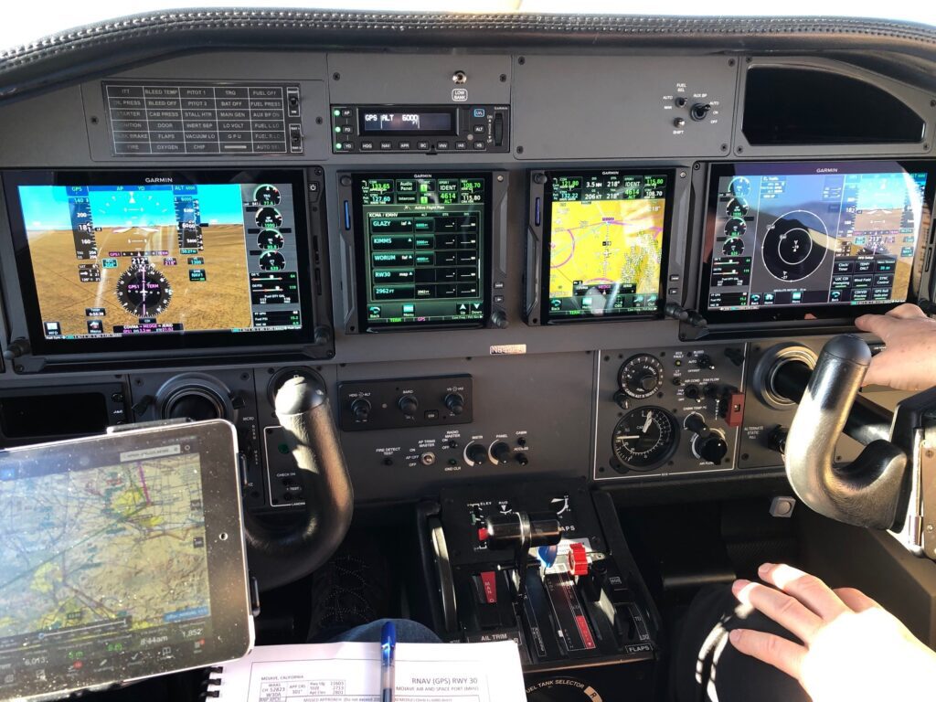
In August 2021, I participated in an inspection flight of a new approach procedure at one of the most challenging airports to land at in the U.S., Colorado’s Eagle County (KEGE) with Hughes Aerospace CEO Chris Baur in a TBM 850 equipped with Garmin avionics. Using the RNP and point-in-space landing capabilities of the aircraft’s advanced navigation systems, Hughes was able to deploy a new RNP AR approach into Eagle County that went live earlier this year.
Equipped with one runway measuring 9,000 feet, the approach to land at Eagle County is challenging because the mountainous terrain and nearby airports that surrounds it making the missed approach procedure challenging for even the most skilled professional pilots. In 2010 as the most famous example, Eagle was ranked as the world’s eighth most extreme airport in a special feature broadcasted by The History Channel.
The airport is situated within a valley inside the Rocky Mountains, with an elevation of more than 6,500 feet above sea level.
The cockpit of the Hughes Aerospace TBM 850.
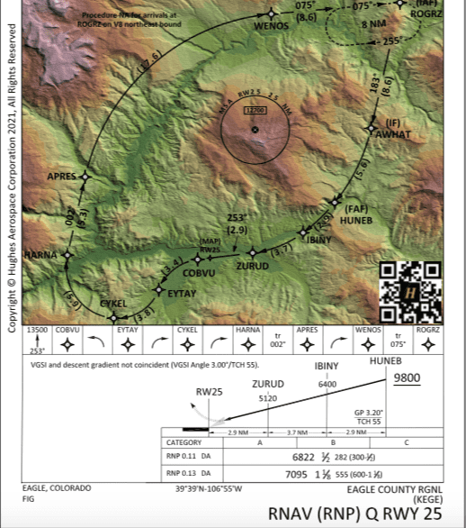
Located 37 miles from Vail, the lone runway at Eagle County is surrounded by mountainous terrain with publicly available procedures that require pilots to use decision heights of more than 1,700 feet and three miles of visibility. Using RNAV RNP, Baur and Hughes Aerospace have established a new approach procedure with a decision height altitude of 282 feet and a half a mile of visibility.
“This approach has the lowest minimums of any published instrument procedure at Vail/Eagle County Airport. The other instrument procedures have significantly higher ceiling & visibility minimums, lack runway alignment, may position the aircraft closer to terrain, and have a challenging missed approach,” Baur told Avionics International.
Flying the approach in the TBM showed how much easier its descent angles and better avoidance of the terrain. The runway is situated within a valley area of the Rocky Mountains, where the mountainous terrain can range from 11-12,000 feet or more.
Pilots must fly over and through a gap in the mountains and slowly descend down into the valley where the lone runway sits to land at Eagle. Visibility can be quickly reduced by surprise snow storms or squalls. Lateral movement of the aircraft is also limited as you descend down into the valley because of the surrounding mountains and terrain.
Hughes Aerospace’s newly deployed RNAV (RNP) Q approach procedure to Runway 25 at Eagle County takes advantage of advanced navigation systems featured in modern cockpits, such as the Hughes TBM 850. It means smoother descent angles for pilots, allowing them to smoothly coast in between the mountains surrounding the downward glide slope into the runway, landing a few hundred over the runway center line.
According to reports on the use of the new approach several airline pilots on the first day of its becoming available through special FAA authorization, Baur said, it prevented several aircraft from diverting.
“Many aircraft today are equipped with contemporary avionics capable of supporting Performance Based Navigation (PBN). Extracting the value of these avionics is achieved through the extensive use of PBN, reducing pilot-controller workload, mitigating terrain & obstacles in a trajectory vs linear based lateral navigation as well as vertical navigation,” Baur adds.
Furthermore, the new approach features the strategic use of radius to fix legs to overfly the lowest possible terrain path from the initial approach fix to the runway. For RNP AR qualified pilots, it becomes a much smoother approach with shallower bank angles into the RF leg turns.
The RNAV RNP approach developed by Hughes Aerospace.
Lowering the landing minimums from decision height in the previously available approaches at KEGE are the clear star of the near approach though. Eagle County is located in the state that receives the fourth-highest amount of snowfall annually in the U.S., often causing lower ceilings enforced by air traffic control at the airport.
According to an article published by the Eagle County airport’s authority in February, the airport set monthly passenger record numbers in 2021, recording its highest number of enplanements from the airport’s lone runway since 2008. Some of the factors the airport attributes traffic growth to include the addition for summer service to Atlanta and Chicago, long with year-round service to Denver.
In 2022, the airport is experiencing continued growth in traffic. American Airlines, United and Delta Airlines conduct the most airline operations of all U.S. carriers to Eagle County, according to the article.
“The automation allows the pilots to focus on monitoring the performance, detecting and reacting to an undesired aircraft state immediately. This is in contrast to ‘being the performance’ potentially becoming task saturated while flying & navigating a legacy process,” Baur said.
ICAO-endorsed air navigation services provider offers IFP and PBN services worldwide.
Air navigation services provider Hughes Aerospace Corp. offers performance-based navigation (PBN) for regulators, airports and heliports, and air traffic management organizations, as well as conventional instrument flight procedure (IFP) design, validation, and maintenance services.
IFP and PBN Services As a fully credentialed non-FAA air navigation services provider, Hughes designs, implements, and maintains IFPs worldwide. Its team is experienced in developing and maintaining Part 97 public and special IFPs. Hughes is also endorsed by the International Civil Aviation Organization (ICAO) as an air navigation service provider. The company, based in Houston, Texas, has participated in airspace projects that involve PBN throughout North America, Latin America, Asia, Europe, and the Middle East.
Hughes’s FAA-approved program includes validation services involving simulator, flight, and obstacle validation for both public and special navigation procedures. The company owns and operates its own aircraft and equipment, allowing it to advertise efficient and timely turnkey responsiveness for both new and existing procedures, including IFP maintenance and NOTAM service for clients.
In addition to holding an ICAO endorsement as an approved air navigation services provider outside of the United States, the company is part of the ICAO PBN Go Team and has worked with ICAO member states on PBN implementations.
The company also holds licenses for IFP design in the United Arab Emirates (UAE), from the UAE’s General Civil Aviation Authority (GCAA); from Oman for implementation in that country; and from the director general of the CAA in the Philippines.
Helicopter and UAS Services Hughes is approved by the FAA to perform heliport evaluations. The company also provides heliport design, implementation, and certification and offers helicopters and uncrewed aircraft systems (UASs) with certification and imagery that can be used in safety and training.
Hughes released its own app, available for iOS and Android devices, in 2020. The app offers weather, NOTAMs, risk assessment, safety management system (SMS) reporting, safety or chart inaccuracy reporting, and the ability to file, activate, and cancel FAA flight plans, among other capabilities.
Post by Alyce Shingler on October 20, 2019,
updated on May 14, 2020
You are cleared for the RNAV RWY 19R approach at Dulles (KIAD) flying the LPV. At LAUGH waypoint, you are at 3,000 MSL and start your descent on the glide path. The METAR shows a ceiling of 300 AGL, just above minimums. You break out of the clouds just before the DA of 478 and land. As pilots, we know of the work it takes for ATC to help us land safely, but are mostly unaware of what it takes to create the instrument procedures themselves. The United States alone has 12,000 instrument approaches, 7,200 of them based upon GPS. Each one goes through a detailed design, test, implementation and maintenance process.
GPS-based approaches are increasing at a rapid rate due to the lower cost and relative ease of design and certification in comparison with VOR or localizer-based approaches. Even with a large number of approaches available, we can always use more, especially at smaller airports, heliports and private landing facilities. As capabilities of satellite-based navigation increase, so do the possibilities for pilots. One of the newest options are curved Radius-to-Fix (RF) approaches, with each leg defined by a radius, arc length and fix. These approaches offer pilots the capability to maintain very precise tracking along curved paths when using approved GPS navigation systems. The first such approach was established at the Ronald Regan Washington Airport (KDCA) in 2003. Another example is the RNAV (RNP) RWY 31 at Palm Springs (KPSP). In order to utilize these approaches, both aircraft and aircrew must be authorized.
The complicated designs are created by the FAA and other government agencies worldwide, along with a small group of private companies. Hughes Aerospace, based in Houston, falls into the latter group. Hughes possesses certifications from the FAA as a Public Part 97 Air Navigation Service Provider, certificated to design, implement and maintain a wide variety of Instrument Flight Procedures (IFR) – particularly satellite-based navigation such as LPV approaches, RNAV SIDs and STARs. Additionally, Hughes Aerospace is certificated by ICAO and several other government regulators worldwide. Hughes not only designs instrument procedures for public airports but they develop and maintain them for private airports and heliports as well.
I reached out to Chris Baur, president and CEO of Hughes Aerospace, to discuss instrument procedure design. Chris, an experienced pilot with both fixed-wing and rotorcraft flight time in the military and civilian arenas, has been designing instrument procedures for more than 10 years around the world.
Chris Baur with Hughes Aerospace was instrumental in the design of a public complex RF approach at Pohnpei International (PTPN) in the Federated States of Micronesia that includes radial-to-fix segments on both the final and missed approach portions of the RNP RWY 9 procedure.
Approaches for Private Airports and Heliports
For private landing facilities such as residential airparks or medical heliports, an instrument procedure dramatically increases the utility and safety. In many cases, a satellite-based procedure is the only solution, especially in environments where terrain and obstacles prevent the development of other approaches. Performance-Based Navigation (PBN) procedures can be designed with either linear or non-linear (also called trajectory-based) flight paths that can provide lower minimums.
With increasing population density surrounding airports and heliports, custom procedures can also help mitigate the noise impact on the surrounding community. Hughes Aerospace has worked on a number of these solutions over the last 10 years.
The design and implementation processes are complex, starting with remote site analysis, which uses a variety of data sources from topographical and aerial surveys to local planning documents. All procedure designs then require a detailed on-site survey. After the initial design, and coordination with the FAA and other agencies, the procedures must then be test flown. Hughes Aerospace uses their own Piper Meridian and Robinson R66 as the test platforms, flying the approaches to verify they meet requirements. Once the testing is complete and the procedure approved, Hughes coordinates the publication of the data in the databases, and in the case of private operators, the issuance of the full-color geo-referenced procedure.
In order for the procedures to be active, they must be monitored daily, including managing the NOTAM service for any changes or variation in service levels. For the majority of approaches that are managed by the FAA, it is their responsibility. For those custom designed for private operators, Hughes Aerospace provides these services.
A 3-D map from a site inspection in Calexico, California. Image Courtesy of Hughes Aerospace
Behind the Scenes Look
I recently accompanied Chris on a site inspection for a heliport in Calexico, California – only a few miles from the airport (KCXL) and a stone’s throw from the United States/Mexico border. Chris and his team already completed initial design work remotely, and the mission this visit was to confirm obstacles and obtain the most accurate data on the helipad and surrounding area.
We flew from Montgomery Field (KMYF) to Calexico in my Eclipse 500 for the site evaluation. The initial ground survey included mapping the obstructions in the local area with high precision, including their latitude and longitude as well as height. Next was the inspection of the landing site itself. Chris made precise measurements of the helipad, then proceeded to use a small UAV to map the location in detail.
I previously owned a photogrammetry company and it was fascinating to see Chris utilize the latest generation of high-resolution technology. The UAV was the perfect aerial platform for this work, flying a precise pattern to assist Chris and his team with creating an accurate 3-D map of the heliport and surrounding areas. This data can then be combined with their other sources to develop the precise paths for the instrument procedures. Each site offers new challenges. This one, in particular, had the Mexico border, large communications towers, as well as buildings near the helipad.
Hughes Aerospace will take this data to design the instrument approach and departure procedures for their customer. And the work won’t stop after the FAA approval since they must monitor and maintain the procedures for as long as they are active.
The next time you are briefing for your instrument approach, or reviewing a departure or arrival procedure, remember that aviation professionals created each one of those altitudes, headings, speeds and notes with an attention to detail – and one focus – safety.